Section 1: Trailhead To Viewpoint 2
The official visitor PDF lists this as 2.53 km, Grade 1, rising from about 1.5 m to 260 m. It is the more approachable part, but still needs shoes, water, weather judgment and care near edges.
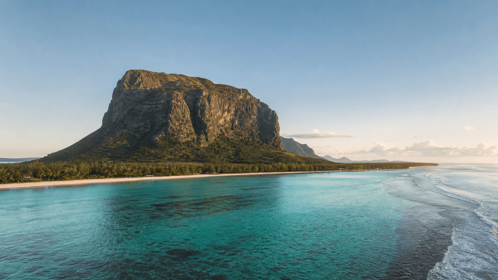
Independent visitor information for Mauritius' UNESCO mountain: hiking, trailhead directions, parking, hotels, beaches, safety, heritage, weather backups and southwest day planning.
Use this interactive map for the Le Morne Brabant hiking start point. From here, visitors can open Google Maps, get driving directions, and check the route before leaving their hotel.
Map checklist
Start with the trailhead, then add the beach, heritage sites, nearby villages, restaurants, viewpoints, and accommodation bases.
Hiking information center
The lower viewpoint walk and the upper section to the metal cross are very different experiences.
The official visitor PDF lists this as 2.53 km, Grade 1, rising from about 1.5 m to 260 m. It is the more approachable part, but still needs shoes, water, weather judgment and care near edges.
This 760 m Grade 3 section is steeper and more exposed, with rock climbing, loose rocks, wind, wet-weather risk and no vehicle emergency access. A liability form is mandatory at the trailhead of Section 2.
Avoid Section 2 if you are under 13, uneasy with height, not properly equipped, in poor health, facing rainfall or strong wind, or unsure about the route. The official trail ends at the metal cross.
Accommodation
Your best base depends on whether you want a beachfront resort, value-focused self-catering, restaurants and boat trips, or a quiet nature stay. Book direct or compare current availability before committing.
This is the most convenient base for visitors who want Le Morne as the center of the trip. Known resort options include LUX* Le Morne, The St. Regis Le Morne Resort, Dinarobin Beachcomber, Paradis Beachcomber, RIU Palace Mauritius and RIU Turquoise.
Often the practical base for independent travelers with a car. It works well if you want lower-key accommodation, food flexibility, and fast access to the trailhead, Black River, Chamarel and the west coast.
A stronger choice if Le Morne is one part of a longer west-coast stay. The morning drive is longer than from Le Morne or La Gaulette, so start early on hiking days.
Good for travelers who want the mountain, the Seven Coloured Earth area, Black River Gorges and a calmer inland or south-coast rhythm rather than a pure Le Morne beach stay.
UNESCO and respect
UNESCO recognizes Le Morne as a landscape of maroon resistance and memory. The mountain, cliffs, caves, village histories, lagoon and monuments belong together. Visit it as more than a viewpoint.
Understand the historySouthwest day planning
Plan the whole day around beaches, lagoon time, lunch, viewpoints, Chamarel, Black River, heritage stops, and weather changes.
Pair the mountain with beach time, lunch, Chamarel, Black River, viewpoints, or a calmer cultural visit depending on weather and energy.
Open the itinerary guideFast answers
Quick routes to deeper guides for hiking, heritage, weather, beaches, and planning.
Guide library
Deeper pages for hiking decisions, UNESCO context, nature, geology, nearby planning, and guided options.
A practical guide to hiking Le Morne Brabant, including trail sections, difficulty, safety, timing, guide recommendations, and what to prepare before you go.
SafetyHow hard is the Le Morne Brabant hike? A clear guide to difficulty by section, who should avoid the upper trail, and what makes the climb feel harder than it looks.
World HeritageWhy Le Morne is a UNESCO World Heritage cultural landscape, what criteria it meets, and how visitors should understand the core zone, buffer zone, and protected values.
Southwest MauritiusIdeas for a full Le Morne day: hiking, beaches, viewpoints, food, Chamarel, Black River, kitesurfing, lagoon time, sunset, and respectful cultural stops.